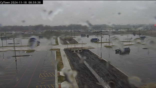
Ames looks a lot like the Pacific Northwest this morning! We are seeing some light drizzle ahead of a warm front to our south. Extended forecasts hint at a more active and snowy pattern by Thanksgiving week. I’m both looking forward to and dreading the change; the weather should be dynamic and exciting with strong fronts (and who doesn’t love fresh snow), but I feel wholly unprepared for the cold and wind! My days of wearing shorts to the gym in the morning will soon be over.
The weather is much more active in the Pacific Northwest this week. On Tuesday, a ~945 mb low pressure system will stall several hundred miles off the Washington Coast, giving breezy southerly winds to the I-5 corridor, stronger easterly winds along the Cascade foothills, heavy mountain snow, and hurricane conditions offshore with wave heights approaching 40 feet! Northern California will see a strong atmospheric river with some locations seeing a foot of rain this week, but with low antecedent river levels and snow levels staying below 3000 feet in many places, no river flooding is expected. This storm reminds me of the 10/24/2021 Pacific Northwest Bomb Cyclone, which reached an astonishing 942 mb and brought widespread power outages to the Eastern Puget Sound lowlands.
November is the stormiest month on average for the Pacific Northwest. This is because the polar regions are cooling extremely quickly but the subtropics are still relatively warm and active, leading to a strong latitudinal temperature gradient with plenty of subtropical moisture injected into the westerlies. During January and February, we can still be quite wet, but the subtropical connection is much weaker and we have fewer major windstorms and floods. If you look at the record crests for Western Washington and Oregon Rivers, the majority of them occur in November or early December. Interestingly, our strongest windstorm on record was also our earliest (the Columbus Day Storm of 1962), but intense windstorms are much more frequent in November and early December and tend to slowly decline after Christmas.
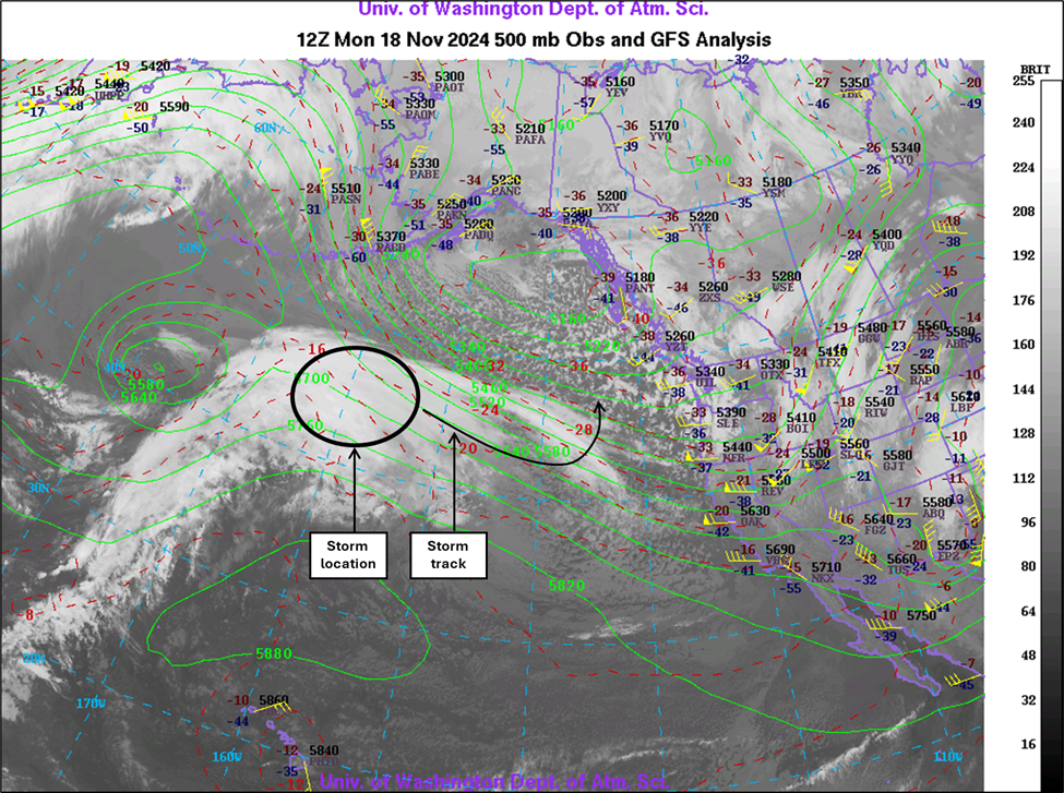
The storm is currently an “open wave” and is just beginning to develop. It is visible on satellite as the mass of clouds and precipitation near 160o West. It will become entrained into a 170-knot jet stream later this evening, which will increase upper-level divergence and allow the storm to strengthen rapidly. Upper-level divergence is necessary for storm strengthening because it transports air away from the storm, resulting in lower mass – and lower barometric pressure – at the center of the storm. The lower pressure at the storm’s center results in increasingly strong pressure gradients surrounding the storm, which result in strong winds. This convergence of surface winds and divergence at upper levels also causes large-scale upward motion throughout the storm, forming clouds and precipitation.
Media outlets (and weather bloggers like myself) often refer to these storms as meteorological ‘bombs,’ but the term has a scientific basis. It was originally coined in Sanders & Gyakum’s 1980 paper ‘Synoptic-Dynamic Climatology of the Bomb,’ where they defined a ‘bomb’ as a cyclone that drops at least 24 millibars in 24 hours. However, I doubt Sanders & Gyakum foresaw just how much the term would catch on with the public at large!
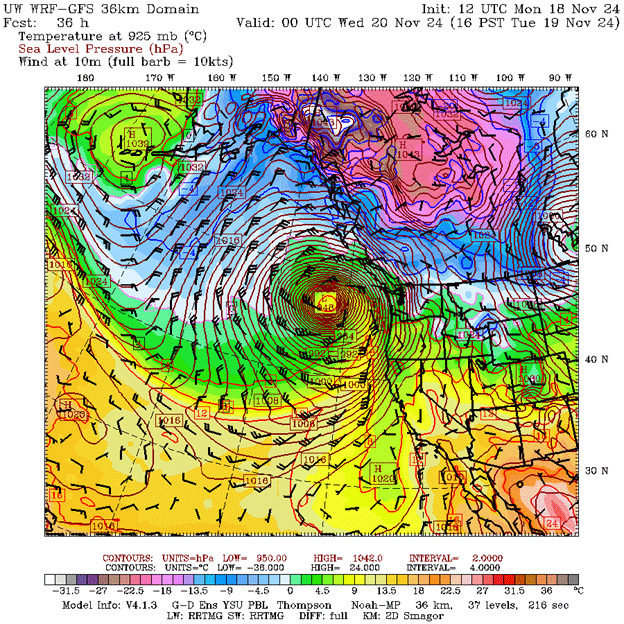
By 4pm today, the storm is expected to deepen to 1010 mb – though it will have abnormally strong pressure gradients due to a strong ridge of high pressure to the south. But by 4pm tomorrow, the UW WRF model shows this storm deepening to 948 mb, equivalent to a category 3 hurricane! Forget about bomb cyclone; this is a nuclear explosion!
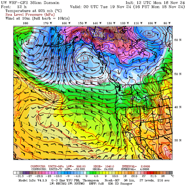
Credit: University of Washington
Credit: University of Washington
Mercifully, the storm will curve offshore, sparing the Pacific Northwest the most severe impacts. The main threats will be the storm’s nearly-stationary atmospheric river slamming into Northern California, high winds and waves along the coast, and breezy/rainy conditions for the lowlands, windiest for the Cascade foothills. Additionally, 10-20 inches of snow are possible at the Cascade passes, so bring chains if traveling and prepare for delays.
If we zoom in a bit, we can see the strong cross-Cascade pressure gradients and foothill winds from this storm. The below model shows gusts of 50-60 knots (60-70 mph) in the Cascade foothills at 10pm Tuesday. The Eastern Puget Sound lowlands will see some power outages (perhaps widespread) from this event. The Puget Sound lowlands west of I-5 will see gusts in the 35-45 mph range… enough to cause a few outages but nothing severe.
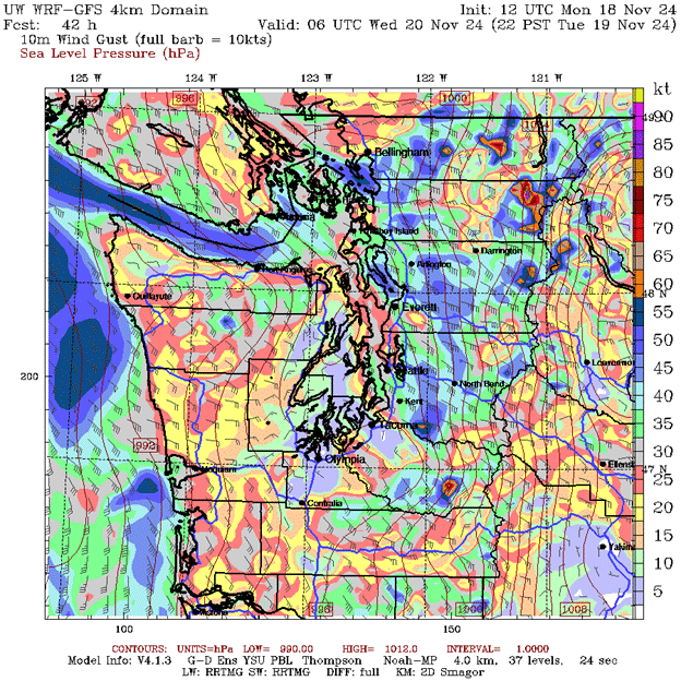
Credit: University of Washington
The Portland metro should see lesser winds (35-45+ mph gusts), but a few outages are possible east of I-405, particularly in the foothill regions which are less accustomed to strong winds than the Western Columbia River Gorge.
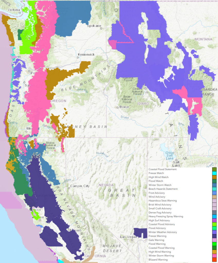
As you’d expect, the National Weather Service has tattooed the Pacific Northwest with multiple watches, advisories, and warnings. Storm Warnings offshore, High Wind Watches for the coast and foothills, and Winter Storm Warnings for the Cascades, just to name a few. Enjoy the storm and stay safe!